| Determined as: | Potamogetonaceae Potamogeton cf. lucens |
| Collected by: | Günther, K.-F.; Schnittler, M., 31.08.2007, Coll.No. 27853 |
| Photo by: | M. Schnittler |
| Determined by: | Schnittler, M., 2007 |
| Herbarium: | KF Private herbarium K.-F. Günther, Buchaer Str. 6 b, D-07745 Jena, Germany |
| herbar scan | 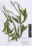 |
| Images |
| 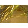
Leaves and spikes | 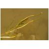
Shoot with spikes | 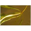
Stem with leaves | 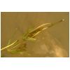
Shoot with spikes | 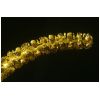
Spike | 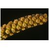
Fruits | 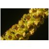
Flowers | 
Underside of leaf |
|
| Country: | Mongolia |
| Province: | Khovd |
| District: | Dörgön |
| Geogr. Region: | Great Lake Basin |
| Next important location: | 6.4-6.6 km WSW Seer (Dörgön), river between lakes Khar-Us-Nuur and Dalay-Nuur |
| Locality: | Seer, northern tip of Agvash-Uul island, plain NNE of the zagon hills, ca. 76 km NNE Khovd, Mongolei, Khovd-Aimak, Senke der Großen Seen, Kara ussu-See (Khar Us Nuur), 6_km südwestl. Durgun (Seer), “in dem schmalen flußartigen Gewässer, welches zwischen der großen Insel im See und dem eigentlichen Nordufer des Sees liegt, nahe der Fähre über diesen “â€Flußâ€"†|
| Coordinates: | geogr. Coord. 92.5514 (lon) 48.3086 (lat) |
| show in map |
| Prec: | 2 km |
| Altitude: | 1155 ± 25 m |
| Habitat: | mudbanks and shallow water of a river, im schwach fließenden Wasser |