| Determined as: | Apiaceae Stenocoelium athamantoides (Bieb.) Ledeb. |
| Collected by: | Günther, K.-F.; Schnittler, M., 05.09.2007, Coll.No. 27960 |
| Photo by: | M. Schnittler |
| Determined by: | Günther, K.-F., Apr 10 |
| Flowering status: | flowering |
| Herbarium: | KF Private herbarium K.-F. Günther, Buchaer Str. 6 b, D-07745 Jena, Germany |
| Collection: | 0 |
| herbar scan | 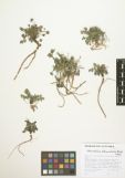 |
| Images |
| 
Flowering plant | 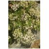
Flowering plant | 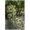
Inflorescences | 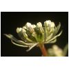
Detail of inflorescence | 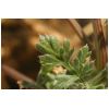
Upperside of pinnate leaf | 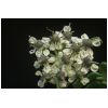
Flowers | 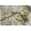
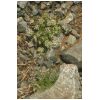
Habit |
|
| Country: | Mongolia |
| Province: | Khovd |
| District: | Chandman |
| Geogr. Region: | Great Lake Basin |
| Next important location: | 59 km S Seer (Dörgön), western slope of Zhargalant Mts. |
| Locality: | at the mound of a large valley of the Zhargalant Mts., Mongolei, Khovd-Aimak, Senke der Großen Seen, Kobdo (Khovd), 23_km nordwestl. Tschandmani (Urdgol), in einem breiten trockenen Bachbett am Fuß der Steilstufe des Jargalant-Gebirges (Dshargalant), an der Mündung eines großen klammartigen Tales |
| Coordinates: | geogr. Coord. 92.5483 (lon) 47.7703 (lat) |
| show in map |
| Prec: | 750 m |
| Altitude: | 2471 ± 75 m |
| Habitat: | first rubblefields near the entry of a large valley, großes Schotterfeld |