| Determined as: | Butomaceae Butomus cf. umbellatus |
| Photo by: | M. Schnittler, 30.08.2007 |
| Determined by: | Schnittler, M., 30.08.2007 |
| Images |
| 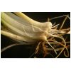
Basis of plant | 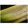
Basis of leaves |
|
| Province: | Töv |
| Next important location: | 6.4-6.6 km WSW Seer (Dörgön), river between lakes Khar-Us-Nuur and Dalay-Nuur |
| Locality: | northern tip of Agvash-Uul island, plain NNE of the zagon hills, ca. 76 km NNE Khovd, Great Lake Basin Seer |
| Coordinates: | geogr. Coord. 92° 33' 5'' (lon) 48° 18' 31'' (lat) |
| Prec: | 2 km |
| Altitude: | 1155 ± 25 m |
| Habitat: | heavily grazed, slightly salt-influenced meadows |