| Determined as: | Asteraceae Artemisia cf. globosa |
| Collected by: | Günther, K.-F.; Schnittler, M., 29.08.2007, Coll.No. 27816 |
| Photo by: | M. Schnittler |
| Determined by: | Schnittler, M., 2007 |
| Herbarium: | KF Private herbarium K.-F. Günther, Buchaer Str. 6 b, D-07745 Jena, Germany |
| Images |
| 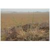
Habit | 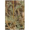
Stem with leaves | 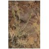
Habit | 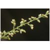
Detail of inflorescence | 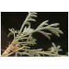
Basis of plant | 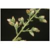
Detail of inflorescence | 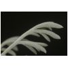
Leaf | 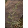
Inflorescence | 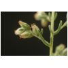
Detail of inflorescence | 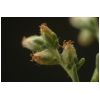
Detail of inflorescence | 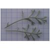
Leaves | 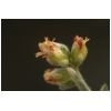
Capitula |
|
| Country: | Mongolia |
| Province: | Khovd |
| District: | Dörgön |
| Geogr. Region: | Great Lake Basin |
| Next important location: | 8.9 km WSW Seer (Dörgön), between lakes Khar-Us-Nuur and Dalay-Nuur |
| Locality: | Seer, northern part of Agvash-Uul island, ca. 3.9 km SW from ferry point, Mongolei, Khovd-Aimak, Senke der Großen Seen, Große Insel im Kara ussu-See (Khar Us Nuur), 10_km südwestl. Durgun (Seer), am Nordrand der Insel, ca._4,5_km südwestl. der Fähre über die schmale flußartige Wasserfläche zwischen dem eigentlichen Nordufer des Sees und der Insel, auf dem Plateau eines Hügels |
| Coordinates: | geogr. Coord. 92.5233 (lon) 48.2822 (lat) |
| show in map |
| Prec: | 1 km |
| Altitude: | 1241 ± 50 m |
| Habitat: | sandy depression between two small rocky hills (granite) , Felsflur |