| Determined as: | Asteraceae Pyrethrum changaicum Krasch. ex Grub. |
| Collected by: | Günther, K.-F.; Schnittler, M., 05.09.2007, Coll.No. 27994 |
| Determined by: | Günther, K.-F.; Schnittler, M. |
| Herbarium: | KF Private herbarium K.-F. Günther, Buchaer Str. 6 b, D-07745 Jena, Germany |
| Collection: | 0 |
| herbar scan | 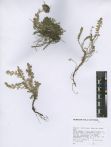 |
| Images |
| 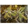
photo by: Martin Schnittler | 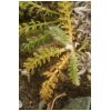
photo by: Martin Schnittler | 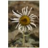
photo by: Martin Schnittler | 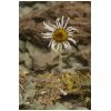
photo by: Martin Schnittler | 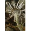
photo by: Martin Schnittler |
|
| Country: | Mongolia |
| Province: | Khovd |
| District: | Chandman |
| Geogr. Region: | Great Lake Basin |
| Next important location: | 59 km S Seer (Dörgön), western slope of Zhargalant Mts. |
| Locality: | , lower part of a ridge leading to the main summit of the Zhargalant Mts., Mongolei, Khovd-Aimak, Senke der Großen Seen, Kobdo (Khovd), 23_km nordwestl. Tschandmani (Urdgol), an der östl. Steilstufe des Jargalant-Gebirges (Dshargalant), an einem nordexponierten Hang, ca._3_km östl. des Hauptkammes |
| Coordinates: | geogr. Coord. 92.5481 (lon) 47.7553 (lat) |
| show in map |
| Prec: | 100 m |
| Altitude: | 2950 ± 100 m |
| Habitat: | boulderfields at the lower part of a W-exp. ridge, feuchte Schotterrinne |