| Determined as: | Convolvulaceae Convolvulus gortschakovii Schrenk |
| Collected by: | Günther, K.-F.; Schnittler, M., 02.09.2007, Coll.No. 27863 |
| Photo by: | M. Schnittler |
| Determined by: | Günther, K.-F.; Schnittler, M. |
| Confirmed by: | Zemmrich, A.; Starke, S., Oct. 09; 01.13 |
| Flowering status: | flowering |
| Herbarium: | KF Private herbarium K.-F. Günther, Buchaer Str. 6 b, D-07745 Jena, Germany |
| herbar scan | 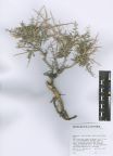 |
| Images |
| 
Flowering plant | 
| 
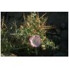
Part of plant with flowers | 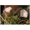
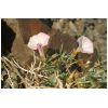
Flowers | 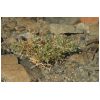
Vegetative Plant | 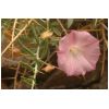
Flower | 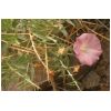
Flower | 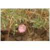
Flower | 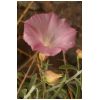
Flower | 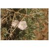
Part of plant with flowers | 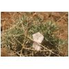
Flowering plant |
|
| Country: | Mongolia |
| Province: | Khovd |
| District: | Dörgön |
| Geogr. Region: | Great Lake Basin |
| Next important location: | 12 km E Seer (Dörgön), E of lake Dalay-Nuur |
| Locality: | Seer, canyon of the Chono-Kharaykhyn Gol river, Mongolei, Khovd-Aimak, Senke der Großen Seen, Kara ussu-See (Khar Us Nuur), 12,5_km südöstl. Durgun (Seer), “ca._2,5_km östl. vom Nordostufer des Sees, im Durchbruchstal des Flusses “â€Tschono charajch golâ€â€, an der Oberkante des südostexponierten Talhanges†|
| Coordinates: | geogr. Coord. 92.7947 (lon) 48.3144 (lat) |
| show in map |
| Prec: | 500 m |
| Altitude: | 1155 ± 25 m |
| Habitat: | open granite rocks, upper part of a S-exp. side canyon in granite rocks, near the campplace, auf Felsen |